What’s going on?
If you’re expecting 15 inches of beautiful snow this weekend, you’re probably in for a disappointment. Your weather app on your phone may be showing upwards of 5-10 inches of snow. However, this number may not represent the pretty snowflakes you expect.
This storm, as we get closer and closer, is looking less like snow and more and more like a mix of sleet and freezing rain. The GFS, or global forecast system, projects nearly half an inch of freezing rain for Raleigh, accompanied by around 1-4 inches of snow and sleet. The European forecasting model is even bleaker, showing over half an inch of ice in parts of the Triangle region.
Nothing is set in stone until the system actually falls. If it shifts North, Raleigh could see over an inch of freezing rain, a devastating total that could lead to multi-week power outages. If the storm jumps back south, Raleigh could get lucky, seeing mostly snow and sleet.
Why is this important?
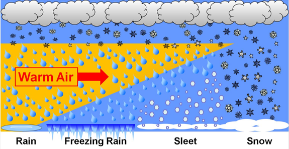
When wintry precipitation falls, it can come in three forms; snow, sleet, or freezing rain. Snow requires freezing air from when it falls to when it lands.
Sleet occurs when precipitation falls as snow, briefly melts in a layer of warm air, and refreezes before reaching the ground. It’s generally icier and messier than snow.
Freezing rain, like sleet, is precipitation that falls as snow before melting in midair. However, unlike sleet, it does not refreeze in midair. Instead, these raindrops remain liquid while supercooling to below freezing. If the ground is cold enough, they instantly freeze upon surface contact creating a dangerous layer of ice.
The amount of total precipitation in a storm is measured as “liquid precipitation”, meaning the total amount of water that would fall if it was frozen at no point.
A storm with one inch of liquid precipitation will cause 4-10 inches of wet, heavy snow to fall, and 10-20 inches of dry, powdery snow to fall. For sleet, this difference is smaller. One inch of liquid precipitation causes 2-4 inches of sleet to accumulate. Freezing rain accumulates at the same rate as normal rain.
Sleet and especially freezing rain are significantly more destructive than snow. Sleet is dangerous because of its high slickness. Driving on a road covered in sleet is nearly impossible, and it sticks around significantly longer than snow.
Freezing rain, however, is the most destructive form of winter weather by far. This is due to the extreme potential for power outages and falling trees it creates; in 2002, when about half an inch of freezing rain fell throughout central North Carolina, nearly a million people lost power, some for a week or more.
What does this all mean for me?
The following is advice from the National Weather Service and other meteorology experts:
- If you’re expecting 5+ inches of snow, don’t get your hopes up.
- Whatever falls is going to stick for a while. Temperatures for the next 1-2 weeks will be freezing, hovering between the low teens and low thirties.
- Use the NWS website for up to date information. It is significantly more reliable than your phone app.
- DO NOT DRIVE AFTER FRIDAY
- Yes, this probably means no or very little school next week. Tuesday, and Wednesday will almost certainly be cancelled. Thursday and Friday are maybes, but will probably at least see delays.
- A remote learning plan is in place for Wake County. Check your classes on Canvas.
- DO NOT DRIVE AFTER FRIDAY
- Make sure that your family has a working generator. If they don’t, heavily consider finding a hotel.
- DO NOT DRIVE AFTER FRIDAY
- Stock up on non-perishables; canned foods and bread are your best bets.
- DO NOT DRIVE AFTER FRIDAY
- There is another winter system forming that could potentially bring snow or ice to Raleigh next weekend as well; it’s too far out to say anything definitive, but keep watching your forecasts.
- DO NOT DRIVE AFTER FRIDAY
Stay safe and stay inside; enjoy the extended weekend, Eagles.
Works Cited
National Weather Service. “National Weather Service.” Weather.gov, National Weather Service, 2025, www.weather.gov/.
“Model Charts for North Carolina (Snow Depth) | GFS (15 Days).” Weather.us, 2020, weather.us/model-charts/standard/north-carolina/snow-depth-in/20260126-0600z.html. Accessed 22 Jan. 2026.